


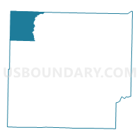
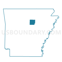
Poff Voting District, Cleburne County, Arkansas
About
Outline

Summary
| Unique Area Identifier | 526143 |
| Name | Poff Voting District |
| County | Cleburne County |
| State | Arkansas |
| Area (square miles) | 30.37 |
| Land Area (square miles) | 29.86 |
| Water Area (square miles) | 0.51 |
| % of Land Area | 98.32 |
| % of Water Area | 1.68 |
| Latitude of the Internal Point | 35.67100600 |
| Longtitude of the Internal Point | -92.20307120 |
Maps

Graphs
Select a template below for downloading or customizing gragh for Poff Voting District, Cleburne County, Arkansas


Neighbors
Neighoring Voting District (by Name) Neighboring Voting District on the Map
- Indian Rock Voting District, Van Buren County, AR
- Morgan Voting District, Cleburne County, AR
- Smart Voting District, Stone County, AR
- Sugar Camp Voting District, Cleburne County, AR
- Turkey Creek Voting District, Stone County, AR
- Union Voting District, Van Buren County, AR
Top 10 Neighboring County Subdivision (by Population) Neighboring County Subdivision on the Map
- Indian Rock township, Van Buren County, AR (2,227)
- Union township, Van Buren County, AR (1,497)
- Morgan township, Cleburne County, AR (537)
- Sugar Camp township, Cleburne County, AR (427)
- Turkey Creek township, Stone County, AR (331)
- Smart township, Stone County, AR (214)
- Poff township, Cleburne County, AR (103)
Top 10 Neighboring Place (by Population) Neighboring Place on the Map
Top 10 Neighboring Unified School District (by Population) Neighboring Unified School District on the Map
- Mountain View School District, AR (12,192)
- West Side School District, AR (4,694)
- Shirley School District, AR (4,501)
Top 10 Neighboring State Legislative District Lower Chamber (by Population) Neighboring State Legislative District Lower Chamber on the Map
- State House District 70, AR (29,754)
- State House District 59, AR (29,163)
- State House District 71, AR (26,638)
Top 10 Neighboring State Legislative District Upper Chamber (by Population) Neighboring State Legislative District Upper Chamber on the Map
Top 10 Neighboring 111th Congressional District (by Population) Neighboring 111th Congressional District on the Map
Top 10 Neighboring Census Tract (by Population) Neighboring Census Tract on the Map
- Census Tract 9501, Stone County, AR (4,003)
- Census Tract 4603.01, Van Buren County, AR (1,812)
- Census Tract 4802.01, Cleburne County, AR (1,492)